skip to main |
skip to sidebar
Rain returns with a downpour as we watch the teams set up in Seaside, CA for the start of Thursday's stage down the Pacific Coast Highway. Donna asked me to get a picture of George Hincapie and Barry's favorite rider is Jens Voight. As if on cue, as Barry and I stood by the Team High Road bus, George just about runs into Barry as he rides up and dismounts his bike! Then we walk a few feet away to the CSC bus and there is Jens sitting in the passenger seat - Barry walks up next to the window and I snap the classic tourists photo. We were able to get close to and see Levi Leiphiemer, Chris Horner, Tom Boonen, Paulo Bettini, Fabian Cansellera, Bobby Julich and many others. The rain really came down at the start, and we were soaked, but not nearly as bad as the riders as they set off for their 130-mile race down the wind-blown coastal highway.
Barry and I drove around some of Monterey and then headed down Highway 1 to find the Bixby Bridge. We crossed over and pulled over to look at an amazing double rainbow over the bridge. For Barry this was the highlight of the trip - he has had the photo of the peleton crossing the bridge up on his office wall since last November. We drove back six miles and geared up for a short, but cold, windy, scenic, strenuous and memorable 12-mile ride.
As we approached the bays that cut into the coast the off-shore wind comes at you after being whipped around the back of the river canyon that made the bay. The result is an amplified wind and rain mix that can come at you in any direction. Combined with the descent coming into these bays and the climb coming out, both of which could have you in a low gear and standing and holding onto the bars for dear life just to keep forward progress, made for a calorie depleting ride.
Finally we get to the Bixby Bridge. The ride over the span was amazingly wind free. The climb up to the rest area was a wind tunnel experience. We returned with the help of the wind we just pushed so hard agai nst. It was nice to have the propulsion, but it was erratic and you still had to struggle to keep the bike upright.
We took photos at the bridge and then continued back to the car. Fifty-five minutes of riding that seemed like a full day. We did a total of 1900 feet of climbing in just 12 miles! Immagine how much climbing and how hard to battle the wind, rain and cold for 130 miles of racing (not riding). A new respect and awe was created today for the racers we have been watching.
Day two of the Tour of California turned out to be a rainy day. Barry and I decided from the weather report to sleep in and go to Santa Rosa for the start, and then see if it cleared off for a ride later in the day. We slept in too long and missed the start, and it never cleared off, or warmed up, enough to entice us to ride. We instead drove around the Napa Valley and scouted some roads up and down the mountains. One road we took, Los Alamos Rd., was amazing in its steep switchbacks and views, but it turned out to dead end at a State Park. We drove up and over Trinity Pass and then stopped at a bike store in Santa Rosa. It so happened the biker out on a break in today's stage, taking enough mountain points to get (and keep) the King of the Mountains jersey, Scott Nydam, lived a couple of blocks from the store. The store was full of people watching and cheering him on.Day Three of our race to follow the race started with a two-hour drive from Sebastipol to near San Jose. We parked our car about two miles up Calaveras Road near a golf course and geared up for the long day ahead. We warmed up with a descent down to the valley and 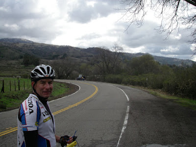 then found our way over to Rt 130 which climbs up to the top of Mt. Hamilton. It is about a 4000 foot elevation change from the valley floor to the top. Turned out to be about a 20 degree change in temperature, too. The climb from the start of Rt. 130 is about 18 miles long. From my reading I knew that in order to bring up all the materials to build the original observatory at the top, they used mules. So, the road was built to accommodate the climbing ability of mules. Mules can not haul much if the slope is greater than 6 to 8%. So, the road at 6 to 8% has to be long, but not steep. Long it is! Most climbing I have done is 8 to 12 miles of hard effort, so it was difficult to judge how hard to go without blowing up before the end. I got into a good rhythm at about a heart rate of 150 and decided I could hold that pace -- about 9 miles per hour, so it would take two hours to do the climb to the top. All these calculations made in the first couple of miles held true. It was great fun to pass and be passed by other riders. Some would pass and then fall back, others I would pass and then they would whirl by, others kept about the same gap behind our ahead of you. No ch
 eering crowds on the mountain today, we were climbing what would be the descent of today's race. We needed to get to the top before they closed the road and made us wait on the side. It was close, I got to the Lick Observatory and a large cop standing in the middle of the road said in a deep, calm voice, "your ride is over." I hit my stop watch and it just turned 2 hours! There were a couple dozen other riders off to the side filling their water bottles and now the pressing issues were: keeping warm, when would the racers come.First keeping warm. I saw a road to the right and going up further. It lead up to the very top and was the Lick Observatory. The building was open, heated and had a bathroom. Also, it had a great view of the twisting snake of a road we had just climbed. I spotted Barry making one of the final few hairpin turns, so knew he would be along shortly. I went in and warmed up, filled the water bottle and then someone said the race is five minutes from going through.
 Unkown rider keeping warm by laying across the hood of running Forest Ranger truck as Donna and I did at Tour of Georgia several years ago -------->We were just a couple hundred yards on the descent side of the KOM mark. It was about 10 minutes until the caravan started to come through. Then we spotted three riders, but no motorcycles. It was Tyler Hamilton and two other Rock Racing riders. They were barred from racing due to doping allegations, but were riding the whole Tour race course for training. The crowd cheered and hooted as they recognized Tyler who wore no helmet and was putting on his wind jacket as he went by. Now the race leaders were coming through with the usual gang of motorcycles and team cars - there was enough of a gap on the main peleton to have some team cars up there. When the main group went through it was crazy - they were battling for position on the descent, putting on their jackets and the team cars were passing each other right in front of us taking up more than the width of the road. The last riders huffed and puffed through in the next 15 to 20 minutes as we all got colder and colder.Now the first priority was to warm up before the long descent. Still no sign of Barry - he had to be up here somewhere. I went back up to the Lick Observatory and you could still see the riders descending down the twisty road. Back into the heated area -- and a bonus, they opened up the other building which had a few radiators pumping out heat like crazy! Off came my shoes and socks to warm and dry. Sitting on the radiator we all talked about what we just watched and how cold the 40 degree air was going to feel screaming down the road at 30 to 40 miles an hour for the first 10 miles. One by one we each left as now it was also a balance of having enough food in you to last until getting back to the car.One more last look for Barry, but not too long as I wanted to keep the warmth I had accumulated to shield against the cold that was coming. I figured he got stopped just short of the top and now was going down, not having the benefit of the heated buildings. The descent was great and it was not long until the air warmed up. You could get up to 40 MPH but all the turns made it more like 20 to 35 most of the way. Not having my own trusty CAAD 4 bike and wheels, I was cautious taking the turns at high speed. The brakes and tires seemed to hold, as long as my arms could be held steady against the need to shiver. As I warmed up and learned the limits of the Trek 1600, it became easier to take turns at higher speeds. It is not often you can spend an hour on a bike, going 20 to 40 MPH and not have to peddle
 - only steer and break. There was more time to see the views as we climbed as opposed to negotiaing the curves on the way down. But on the way up I did not want to stop in order to keep a good rhythm and pace going. So I stopped on the descent several times to take photos and take off the jacket on the last third of the descent.View from Mt Hamilton Road about 1/4 way up looking towards San Jose ---->Finally, at the base of Rt. 130 I spotted Barry waiting for me. We high-fived and chatted about what we just did and witnessed. It was a fun flat ride over to Calaveras Road, but not before we had to stop and watch the last rider come through the finish circuit. The two-mile climb back to the car was a reminder of what we had done for 18 miles earlier in the day. The day's total was 50 miles and 5500 feet of climbing, and many good memories.
For the second time in three years I am off to ride parts of the Tour of California professional bike race and be part of the cheering crowds at the tops of the peaks and starting lines. This time I have a partner - Barry, who I met at a Cargill meeting in Minnesota. We found out we shared a passion for both riding and following professional cycling. When I told him about the trip I did in 2006, and my plans for 2008, he wanted in. Since Donna will not leave Alix and the dogs to others, it is great to have someone to share the experience with.The first day we met up at the Sacramento airport, rented a Rav 4 and loaded our gear. I brought my snowboard stuff so I can perhaps make a trip to the Sierras at the end of the week, before I start working for Cargill out here. We found a good, inexpensive motel near Folsum where we rented our Trek 1600 bikes and then set off for Sausillito. The day was to get the bikes checked out and to get our bodies somewhat used to riding after our long winter hiatas from riding on the roads. We repeated a trip I have done twice before, last time with Russ back in April. Parked the car and took the bike path to the Golden Gate, then over to Fisherman's Wharf and back across again. This time we made a left and took the nice two-mile, 800-foot climb to the top of the road that overlooks the bridge and the city. The climbing legs woke up and Norm and Dan's spin classes apparently paid some dividends.After spending the night in Sebastipol, we set off to get a first look at the race. From my scouting here two years ago I was able to make a great route of about 40 miles and 5000 feet of climbing. We went down to the quaint village of Occidental nessled in the redwoods. Then climbed a little on Bittner Rd before taking a screaming descent down Joy road - aptly  named. Now we were down to the main road to Bodega Bay - Pacific Coast Highway 1. But after only a mile or two we took the cut across behind the town of Bodega Bay called Bay Hill Road - a narrow, twisiting four mile paradise with huge eucholptus trees. The views up into the valleys was only surpassed by the first glimps of the Pacific ocean as you take a turn through the trees. We come back out on PCH only about a mile ahead of the turn up famed Coleman Valley Road. This is the King of the Mountain point of today's race and we are there about 1 1/2 hours ahead of the race leader.I first experienced Coleman Valley Road two years ago after I watched the race up by Sebastipol. I meet Charles
 , a local painter and cyclist, there and he took me down this road and I returned to Sebastipol the way we came down to this point today. The road climbs from sealevel to about 1200 feet in about 3 miles. The KOM point is only 1.6 miles in and at about 800 feet. There were many cyclists making the climb and lots of spectators trying out there cow bells and cheering us on. This is one of the highlights of riding race routes on race day. It took me about 15 minutes to get to the KOM point. So, from experience, that told me the racers will do it in about half of that time. Barry and I found a good spot a couple hundered feet from the KOM mark and began to shiver and wait. The clouds were hea
 vy enough to block the sun and the wind off the ocean was just enough to keep you from staying warm. We huddled close to the ground and survived until the race arrived. Cows came out to see what all the fuss was about and then finally the race leader - off the front by 11 mintues came up to us. The rest of the peleton was pretty much together and hot in persuit. You could see they were suffering as the riders pumped past us. Barry picked out Jens Voight (his favorite), Tom Boonen and others. No one waited around long after the sweeper passed and the cyclists were about spit in half, each going a different direction. Our direction involved a little more climbing, which helped us warm up.The ride back was amazing. We once again decended into the town of Occidental and found a festival of cyclists there. Two years ago, when I arrived in this village after the long climb up Joy,
  the place was abandoned and I was hypoxic and lost - finally going the long way back. This time I knew how to get us back on Occidental Road and after a short, steep climb it was a great decent and roller coaster of fast hills all the way back. Barry and I were all smiles as we made the turn to take us back to the hotel. In the hot tub we talked with three guys down for the race and riding from Oregon and others. Soon we were tabled up to some more great Mexican food at the restaurant next door. Tommorow looks like rain, so we may just watch the race start in Santa Rosa, and the ride in the afternoon if it clears off.
 Highway. Donna asked me to get a picture of George Hincapie and Barry's favorite rider is Jens Voight. As if on cue, as Barry and I stood by the Team High Road bus, George just about runs into Barry as he rides up and dismounts his bike! Then we walk a few feet away to the CSC bus and there is Jens sitting in the passenger seat - Barry walks up next to the window and I snap the classic tourists photo. We were able to get close to and see Levi Leiphiemer, Chris Horner, Tom Boonen, Paulo Bettini, Fabian Cansellera, Bobby Julich and many others. The rain really came down at the start, and we were soaked, but not nearly as bad as the riders as they set off for their 130-mile race down the wind-blown coastal highway.
 nst. It was nice to have the propulsion, but it was erratic and you still had to struggle to keep the bike upright.